
Given geo-spatial data, have you got into a situation to do the analysis on an area or city or country level? Have you wondered how to map the latitude and longitude information to unique grid id without any external libraries? Then this might help you.
For example, let’s take a sample coordinate and calculate the grid id for that.
59.325025, 18.070753 (one of my favourite location at Stockholm)
What do the decimals in the coordinates mean?
Before getting into the calculation of grid-id, we should understand the details of the decimal points in the latitude and longitude coordinates.
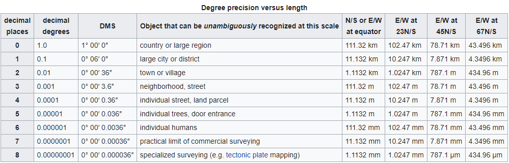
It’s simple, isn’t it. As the number of decimal points increase we are getting precise with the location.
Problems in creating grid id using just lat and long
For simplicity, let’s create grids of a country-like or equally large area like areas.
Then we can remove the decimals in the lat and long.
round(latitude), round(longitude)
59.0, 18.0
Since the values of lat and long has both positive and negative values, we cannot directly use them as grid id
Why? Let’s see with some examples.
| Grid-id | |||
|---|---|---|---|
| Possible Combinations | round(latitude) * round(longitude) | round(latitude) - round(longitude) | round(latitude) + round(longitude) |
| 59, 18 | 1062 | 41 | 77 |
| -59,18 | -1062 | -77 | -41 |
| 59, -18 | -1062 | 77 | 41 |
| -59,-18 | 1062 | -41 | -77 |
We can remove multiplication operation, as it produces duplicates within the possible combinations of the coordinates.
There is also a problem with subtraction and addition because the same values could be produced in many possible ways. For example
| Combinations | Grid-Id |
|---|---|
| 70,7 | 77 |
| 69,8 | 77 |
| 90,-13 | 77 |
Why this is not possible?
The space between every latitude circle is one and we need to fit 360 longitude sections within them.
Solution
So if we make the space between two latitude values large enough contain all longitude sections, then the problem gets solved.
Since we are considering, one unit space between latitudes and the same for longitudes We transform our equation to
360 * round(lat) + round(long)
| round(lat) | round(long) | round(lat) + round(long) | 360 * round(lat) | 360 * round(lat) + round(long) |
|---|---|---|---|---|
| 59 | 18 | 77 | 21240 | 21258 |
| 59 | -18 | -41 | 21240 | 21222 |
| -59 | 18 | 41 | -21240 | -21222 |
| -59 | -18 | -77 | -21240 | -21258 |
| 70 | 7 | 77 | 25200 | 25207 |
Thus by multiplying latitude with 360 we are able to generate unique grid id for all possible longitude.
GRID_ID = 360 * DEGREE * ROUND(LAT*DEGREE) + ROUND(LONG*DEGREE)
I would like to thank my colleague Jakob Rogstadius for passing on this knowledge to me.

Leave a comment